Sunday, July 30, 2017

July 30th 2017
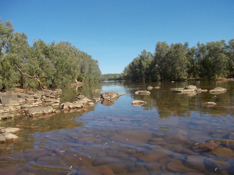
Reflections in Ellery Creek Big Hole

We have had a lovely day exploring two more Gorges along the West MacDonnell Ranges. Firstly we visited Ellery Creek Big Hole which is a most popular place with both a Camping Area and Day Visitor facilities. From here we walked the Dolomite Track which is 3 km in length. It follows the Larapinta Trail for 1 kilometre and then loops around the hills and returns to the Camping area. It was rocky rough but with my faithful stick I managed the distance quite well. The close view of the country, the rocks and plants was part of the pleasure.

Last year, at about this time, Cynthia and David  walked the 240 km long Larapinta Trail. It took them about 12 days from memory. When I see the West MacDonnell Ranges in reality it makes me realise what a mammoth effort it was..beginning  in Alice Springs and finishing at Redbank Gorge and climbing Mt Sonder which is a stately mountain overlooking the whole range. It is not the highest mountain in the Northern Territory as this honour goes to nearby Mt Zeil.

Early afternoon we walked the 1.1 km, from the Carpark, to see Serpentine Gorge. I found the walk a little arduous as the day was quite hot. Unexpectantly , we found the Gorge to be quite Spiritual. There were over a dozen people there and everyone was totally quiet. So quiet that we felt we were waiting for the music to begin. We both found the experience to be totally remarkable.
Mini Richie Bark

Now where to Camp? We drove up to the Henderson Lookout to see the view..the sign said ‘Twenty-four hour camping allowed’…So here we are up on high for the night with a magnificent view of the West MacDonnell Ranges. There is a ‘Hot Spot’ up here so we can gain telephone connection so we were able to ring Cynthia. With the help of the Dongle I am able to 'Post' a couple of blogs..but no photos.


These Ranges are very different with so many rocks visible along the top and side of the hills. In places there is little or no soil and only a few trees and spinifex in view. John has coined the phrase ‘the bones of the earth’ are visible! It is an apt expression. I can see a long snake or dinosaur making its way along the tops of the mountains. 
 July 29th 2017.

We have had a varied day with some travelling, saying Good bye to ‘Alice Springs’, driving west to refresh our memories about the West MacDonnell Ranges and enjoying the warm weather. These Ranges are striking all over again with rugged red/brown rocks showing layer upon layer of sheer drops of rock and earth with a small amount of grasses which could be spinifex mixed with some small eucalypt ghost gums. Along the wide dry river beds there are River Red gums which are similar to those we have at home but are slightly different.. a different sub-species. They are delightful trees with white/grey/ brown trunks and wide spreading limbs.
Firstly  we drove into Simpsons Gap which has a wide dry river bed but with quite a large pool of water in the Gap. The cliffs are rough, sheer, rocky and a deep red/brown colour. We made the short walk along the sandy river bed to the Gap to the large pool water.

Onward to Stanley Chasm. This Tourist spot has become quite commercialized. We could not find a park unless we walked for a kilometre. Many years ago we went into the Chasm itself to see the sun shine directly down for a few minutes around midday. We did not wait for this but saved the image in our memories. Interestingly, late last century, I purchased a beautiful dress and shawl, which had been hand dyed and made by Trudy Billingsley. The colour of the dress had been inspired by Stanley Chasm so, as you can imagine, it is a delightful brick orange colour similar to the rocks of the West MacDonnell Ranges. I really love this brick red orange colour.

Water in Simpsons Gap

From here we branched onto Namatjira Drive, guided by the map about the West MacDonnell National Park and assisted by Wiki Camps we left the main road, and followed the sign post to Hugh Gorge. We had not heard of this Gorge before. The road was very rough so we found a lovely flat camp on the banks of the Hugh River which of course was dry. After setting up camp, we ate our lunch then set off, without the van, to find Hugh Gorge and Birthday Waterhole. The road/track was wild, rocky and rough so eventually we turned back and slowly came back to our camp and enjoyed a relaxing few hours under the shade of a large Red Gum tree. There are no birds or animals here…presumably because there is no nearby water. The area is very dry and flowers are yet to bloom.

Friday, July 28, 2017

July 27th  & 28th  2017... Alice Springs 

This morning was certainly cooler..a warning of southern temperatures I am sure.
We had quite a long chat with Bronwen and Graham before we finally left about 9.30. The W.W.2 Staging Camp provided a great place for free camping. It is open and uncrowded with is space for many camping rigs.

The Stuart Highway provides easy driving, with some very pretty views of the undulating country, especially the mountain ranges. There were several magnificent Mesa Hills. The rocky tops were stark and sheer and I imagine nearly impossible to climb. There were many rest stops along the way, the most interesting one was the Crossing of The Tropic of Capricorn. We also passed the turn off onto the Tanami Road where we have travelled several times in earlier years.

I noticed that there were many roadside trees which were infested with Mistletoe Maidenii. It is different from other mistletoes in that it has glaucous grey/green leaves and the flowers are the same colour as the leaves.

We saw Graham & Bronwen several times along the road--- eating lunch and stopped at a roadside service station...all quite unplanned! 

We arrived in Alice Springs mid afternoon and have camped in the Big 4 Park. It is a clean and well cared for park. We went to a nearby Tavern for dinner. 
Driving Through Heavitree Gap in Alice Springs

The second day in 'Alice' was busy firstly with laundry chores and Super Market shopping to stock up on supplies for the next week. We did enjoyed lunch with Gary Renkin at the nearby 'Star of Alice Cafe'. Gary kindly spent some time with John checking out his 'mal-functioning CB radio'...unfortunately without much success.

I had arranged to meet Bronwen for a couple of hours wandering through shops in the Alice Springs Mall. We enjoyed all the Art Galleries especially. Eventually we found a Patchwork & Quilting Shop which appeared to stock only 'Aboriginal Designed' fabrics. They were lovely bright fabrics typical of the designs used in the local paintings. I was pleased to purchase an unusual brick-red piece.....cushion covers maybe??

Friday night we went to 'Barra on Todd' which is a really great restaurant with a large range of meals. John & I both chose a lamb meal...the last lamb chops were purchased in Winton and were less than satisfactory. Bronwen and Graham joined us so we enjoyed a fun night with good company, good food and good wine.


 July 26th 2017

We left the lovely camp on Whistle Duck Creek at around 9.00 am. It was quite a good trip out through the bush and lots of dry creek beds, some  of which show a flood depth of 2 metres..this is surprising but debris is visible high in the tree branches, so it must be a realistic measurement.

I was lucky to see a Mistletoe Maidenii as we drove by. The leaves are quite grey/green glaucous in colour and so are the flowers. Another plant I saw on passing was the Cockroach bush which belongs to the Cassia family.
We were lucky to be able to follow the grader as he worked on the very roughest part of the road. We passed him and were travelling slowly along the section of road which was set aside for traffic when a vehicle and van raced passed us on the wrong side of the road and amid the dust. Surprise surprise!!

Back on the Stuart Highway again we soon came to the Devils Marbles. What an amazing arrangement of huge rounded rocks. Further south we stopped in at Wauchope with the plan to buy fuel and found it to be $1.79 per litre so we only put a small amount in the truck…we will wait for a cheaper option!

We camped the night on the old World War 2 Army Staging Camp. It is a deserted wide flat space with some concrete pads which are most suitable to park a van on. We had been there an hour or so when who should appear, walking toward our van but my good friend Bronwen Menner. She and her husband Graham were camped in the area as well. We spent some time chatting with them and will catch up again in Alice Springs where we should arrive tomorrow some time.There are about 15 or 20 rigs camped on this free site. We had a view of Taylors Creek which is a wide dry and sandy creek bed.


July 24th & 25th  2017  Davenport National Park

 The ‘desert wind’ following us all day from The Pebbles/ Kunjarra  onto the Stuart Highway and continued most of the day. The highway is a wide bitumen road with distant inland mountains making the scenery very attractive.

After visiting Tennant Creek, which is really much larger than I had remembered, we turned east onto the Kunara / Epenarra Road which was gravel and has brought us here to The Davenport National Park. The road was rather rough in patches but the variety of plants and trees provided a great deal of interest. In fact I had to request several  ‘photo stops’. I could not identify all the trees ..wattles, eucalypts, hakea, grevillea, cassia and melaleuca with many in flower. The drive through the beautiful red-rock hills toward the Davenport Park was quite a slow journey but eventually we camped at a waterhole on Whistle Duck Creek. It was a pretty spot and the water  proved to be clear and clean..maybe some washing. We have paid to stay for 2 nights.

During the early morning we heard dingoes howling and both nights a donkey neighing ‘Hee Haw’

The second day has been fine and warm. We went off for a short walk along the Injaidan Waterhole. The water looked deep and was flanked by a magnificent sheer rock face wall. The trees show a collection of debris collected during the last flood. There is a huge variety of trees..several gums and several wattles one of which is the low growing Curry Wattle that smells distinctly of curry when you rub the leaves in your fingers.

Back at the camp we have spent quite awhile watching and trying to identify the birds which include a Rainbow Bee-eater, Zebra Finches, Corellas, a Straw Necked Heron, a Black Cormorant, Lincoln Ring Neck Parrots, several Butcherbirds, Pigeons and several very tiny honeyeaters.

Our day has been restful and definitely what was needed after the drive in on the hilly gravel road…tomorrow we will attack it again..perhaps an early start. I am about 30 minutes ahead all the time because of the time difference in NT!


Late morning on Monday, David & Cynthia were to leave Alice Springs. David will have set out to drive his truck  home, carrying the 2 motor bikes and Cynthia will have flown to Melbourne to be collected and taken to Oxley by Helen & Neil Brock.

Sorry, no photos tonight as the 'server cannot be found'!

Sunday, July 23, 2017

July 23rd 2017


The bitumen surface of the Barkly Highway allowed us to be on the Stuart Highway by lunch time...the first sign after we left the Roadhouse told us that the speed limit was 130...we are not accustomed to that in Victoria and we certainly cannot tow our caravan at that speed!!

The bush-land either side of the road was low with a few Bloodwood trees showing their high blooms. Grevilleas and acacias were also in bloom but we were unable to stop. The only one I could identify while travelling was the Holly Grevillea. We have been surprised over the weeks we have been travelling just how many burnt patches there are. I am unsure how these fires start. Often I think the bush benefits from being burnt with a low fire because some seeds need the heat to crack them open ready for the first rain

Red Bud Mallee Eucalypt in bloom
Again there were many quite large termite nests. Some had a point of difference because they had been dressed in discarded  clothing to make them look like people! One even had a 'roadworks' witch's hat on to give a look of distinction!

 Three Ways Roadhouse is 187 kms from the Barkly Roadhouse. There was phone connection at this busy place, so we sat for awhile in the shade and ate our lunch then made a couple of phone calls. While this was happening I noticed a Red Bud Mallee eucalypt in bloom...a very distinctive tree.

We have driven out to the Pebbles Tourist site
Grey Cassia with yellow blooms and green seedpods
this afternoon and set up camp for the evening. There is only a very short walk here so that is disappointing. However I did find a couple of attractive Cassia bushes in bloom. The weather is a comfortable temperature but very windy. Toward evening we have realised that many other people have had the idea to camp here with us..luckily we are in the corner of the small fenced area.

Good news today as I have been advised that my quilt, entered in Art Quilt Australia 2017 has been accepted. 50 quilts have been juried in, for display, out of 76 entries.

Saturday, July 22, 2017

July 22nd 2017
View of Mitchell Grass on Barkly Tablelands...photo taken while travelling.

Today we completed the trip across the Barkly Tablelands driving over 300 km along a bitumen road of varying quality to reach Barkly Homestead Roadhouse about 2.00 pm . We crossed both the Barkly and Rankin Stock Routes along the way. The scenery varied from open bushlands to wide open plains of Mitchell Grass. Again the Silver Box tree was in evidence along with Bauhinia trees displaying large deep red seed pods. The cream grevillea which we have seen in the last few days were in bloom in a couple of spots and bloodwoods again but displaying large decaying flowers.
Bauhinia pods with our rig in the background

We were delighted to see 4 Bustards on the roadway so we could get a good view of them as they took flight. Wedge Tailed Eagles regularly feed on the roadside carrion. They always leave it until the last second to take flight away from the vehicle...they are large bold birds and amazing to watch with very wide wings.

We passed a team of operators doing seismic tests and laying out many kilometers of cable in readiness for the testing of minerals we presume.

We are staying in the camping ground attached to the Roadhouse. It appears to be a well organised establishment. It is situated on the Barkly Highway which is a very busy east-west route for travellers.
July 21st 2017 

Our day has been busy but rather uneventful apart from being woken by the sounds of the Blue Winged Kookaburra practising his laugh. We packed our rig then drove up the street to fill with fuel and restock our refrigeratror with enough food to get us to Alice Springs. There are 3 Supermarkets in Borroloola which have provided us with all our needs. We visited this town some years ago and it is remarkable how the  buildings, the general tidiness and the appearance of the locals has improved. They have every right to be proud of their township.
Rock formations at Caranbarini Reserve

We headed south along the Tablelands Highway to Caranbarini Conservation Reserve. We have visited this interesting area before but we still enjoyed our walk through the wonderful rock formations. Yellow rod blooms on unidentified wattles provided colour as did the bright orange flowers on the very high branches of the Darwin Woolly Butts (Eucalyptus Miniata).

The directions on the information board suggested that the Barrawulla Loop of 2 km would take 1-2 hours but we made our return in a little under one hour. After we enjoyed our lunch we walked along another track to the Caranbarini Waterhole which has a bird-hide overlooking the water which has large waterlilies growing in it. We quietly watched a number of 
Green Pygmy Geese. They are not very big birds but have interesting markings including lustrous green wings

Waterlillies at Caranbarini Waterhole
The Tableland Highway has continued south to Heartbreak Hotel at Cape Crawford where we did consider staying but eventually drove a good way south and parked on a roadside stopover on the edge of the Barkly Tableland. It is flat and dry with little shade but my washing is on the line and we will enjoy some Borroloola sausages for dinner.


I have neglected to mention that John has had two events with a tic… digging into his wrist firstly then into his upper leg. Nasty things, we were able to pull them both out/off with a pair of tweezers.


Thursday, July 20, 2017

July 20th 2017

Cream Grevillea
A cool morning with a brisk breeze. We left our campsite about 9.00 am and little did we know what a rough road we had ahead of us. It took us nearly 3 hours to drive 160 kms. John was driving very carefully avoiding any big holes. There are many burnt out cars on the side of the road, one of which looked like a 'holiday rig'...such disaster.

The Robinson River country and bush is flat with open forest. It is Aboriginal Land which is also know as 'Mungoobada' . We crossed the waters of the Robinson River which were in a deep valley and of course there are warnings on all waterways to be aware of  Crocodiles.

Orange Grevillea

It was great to see several Grevilleas in bloom. Those close to the road were covered in red dust so I had to wait my chance for photography. They were all new to me but hopefully I will eventually find out their names ..at the moment cream , orange and red grevilleas.

Some areas were lush and tropical in appearance with many 'cabbage palms' growing. Termite nests are plentiful and quite large made from 'clay' coloured earth.


Red Grevillea
There were a few horses in the bush, one single healthy dingo and a Blue Winged Kookaburra. These  northern birds have much more blue on their wings than the Victorian Laughing Kookaburra. they cannot laugh like the ones we see and hear at home, they only sound as if they are practicing and never really laugh heartily.

The last River we drove through was the Foelsche, it was flowing quite swiftly and made a great photographic topic.


After arriving in Borroloola we decided to camp in the Caravan park which is pleasantly green with space between vans. John unlocked the Jayco and with a gasp....look what has happened. To our disappointment the Microwave oven had come off its mooring and was sitting on the floor. Amazingly there is little damage..a few scrapes on the floor. The glass plate from inside the oven was unharmed. We are most fortunate that there is so little damage. I do not use the Microwave as we rarely plug into Mains electricity and could very well use the space to better advantage.

We drove toward the coast from here about 60 km and saw the Fishing Camp at King Ash Bay where there were many camping rigs and boats. Obviously fishing in the Gulf is very popular.

Tonight we ate at the only local restaurant where each of us thoroughly enjoyed a huge plate of local  barramundi. Our day is complete!  Yes, I have been speaking to Cynthia who is still resting in Alice Springs. Her recovery is gradual.

I
July 19th 2017

Today has been interesting as we have travelled ‘The Great Savannah Way’ which is the closest road to the coast of the Gulf of Carpentaria. The coastline is quite difficult to reach as Famous explorers ‘Burke and Wills’ found out. Mangroves grow in a wide band around the coast sheltering sand flies, mosquitoes, crocodiles and other evil creatures that would harm you if you step into the water. The water is so very aqua blue and inviting but it is not for us.
The road has been very rough and very dusty in some parts while other sections have been sealed with bitumen. There seemed to be a lot more vehicles today as well. Driving is quite a challenge dodging potholes, bull dust baths and corrugations. Apart from these comments we have enjoyed the scenery which has taken us through  the Calvert Hills which were very attractive with a new range of trees.
Jabiru
We have seen termites nests on many occasions before today but as we progressed they seemed to become bigger and much closer together. Silver Box trees are still with us as well as some coolabahs, the tall Darwin Woolly Butts, Grevilleas, one type with  bright orange flowers and a smaller bush with cream blooms. The dust settles on nearby bushes and actually spoils their brilliance but at last I found a clear pink Star Bush..there were many of these. We have seen waterlilies in several waterholes. Also a wonderful Jabiru wading in a road side water hole.
Star bush
I was not looking forward to visiting the settlement called Hell’s Gate as last time we called there it was dirty and inhabited by very unsavoury people who were fighting and using nasty language...pension day I think. What a surprise to day to find green lawns, freshly painted buildings and a neat camp ground. I was able to log onto Roaming WiFi for a small price and so my blog has been updated today. Tonight we are well away from Internet connection as we camp on a rise near the Mc Graggan Creek.
West of Hell’s Gate we came upon a lone cyclist..a young, tall and very thin French chap peddling his bike across the top of Australia…what a way to see our great country.
We came by an unexpected Copper mine where there was a notice advising people not to use the water. The creek was polluted with white and green crusts of copper waste.

We crossed the Calvert River through flowing water and rocks..only to find our first sign warning of crocodiles…we will be very aware!! There was a very attractive Oasis on the west side of the Calvert with a spring bubbling water down to the river..
Crossing the Calvert River


Wednesday, July 19, 2017

July 18th  2017

We left Lawn Hill this mid morning after a phone chat with Cynthia . We are much relieved to hear her voice on a much stronger note. Later in the day we received a short message from her to say she had passed all the tests for concussion and was allowed to leave this afternoon.

We have had an interesting day driving north of Lawn Hill, through quite remote country, to join the Savannah Way at Doomadgee. Like every day we travel, the scenery is ‘ever changing’ . Firstly we drove through Lawn Hill Station past the stockyards and homestead, which was high on an escarpment. The range of rocky mountains in the distance were beautiful purple and red rock colours. Cattle were in mobs around every waterhole. Many horses were about as well. The station roads were quite good to travel on but dusty. There were very few other travellers coming our way today.

We crossed Lawn Hill Creek several times. Eventually we found a shady place to have our lunch. It was on a lagoon which was part of Elizabeth Creek. The bird life was interesting in that we saw two large Black-necked Storks which are very often known as Jabirus. There were Pelicans on the waterholes as well as Black cormorants and various other herons and ducks. Water birds are always fascinating to watch.

Kapoc trees
Apart from the many Silver Box trees there were some new trees today including, what I think are ‘Whip-stick Wattles’ which a slim willowy tree that sway in the breeze. Then we came upon several Kapok Trees. I immediately think of kapok  mattresses. The trees have quite large yellow blooms as well a fruit which look  like Feijoa fruit. When these oval green fruit are cut they have a soft cotton like filling covering the seeds. The white 'fluff' is just like the old fashioned Kapoc filling. 

Fruit and flower from the Kapoc tree


We purchased fuel at the Doomadgee Roadhouse at $1.73 per litre. Further west we have camped at Walford Creek Camp. It is a small clean area and at present we are the only campers here. The flies are very nasty, in fact it is really the first time that flies have bothered us during the time we have been away.

   
July 17th  2017

 The weather is delightful..cool nights with warm to hot days. It certainly promotes R & R or laziness ..however you look at it.

Last night we decided on a walk today. John wanted to do the ‘Island Stack’ walk which was listed as ‘difficult’..this always makes me feel hesitant. The details said to allow 2 hours of walking time. The initial ascent was very steep and we had to come down these same rocky steps. The 1.6km walk around the ‘table top’ gave us impressive panoramic views of the surrounding country and the beautiful and colourful  gorge cut by Lawn Hill Creek.
Red rocks on top of 'Island Stacks'
The country on top was mostly red brown rocks but there had been a fire through during the last year or so.

Bench seats provided us with a resting place high above the many palms that grow along the creek. It also provided us with phone connection which is not available in the valley. We took the opportunity to ring Cynthia in the Alice Springs Hospital. She is still suffering from concussion but improving a little each day.

By the time we came down to the valley floor, had a walk through the NP camping area and returned to our vehicle we had been walking for  2.5 hours and felt quite hot.
June in front of a fig tree which has grown through a crevice in the rocks

Back here in Adel’s Grove our rig was shaded and a welcome spot for lunch. About 2.40pm we walked down to the swimming hole and enjoyed a cooling ‘dip’
The day was nearly gone by then, a little washing, a cool drink and some stitching. The time is easy to fill in but we must continue on our journey tomorrow as we gradually head toward Alice Springs.


July 16th 2017

Surprisingly it was quite cool during the night, but the day has warmed to about 26 deg which is very pleasant.
Our start for the day was not so pleasant. John checked our Satellite phone for messages only to find that Cynthia has had a nasty fall from her motor bike in the northern section of the Tanami Track. She was riding with the 'Trek the Track' team of riders. It is unfortunate that this had happened but her injuries are not really serious. She was transported by RFDS plane to Alice Springs Hospital last Friday. We have been able to speak to David a couple of times and I have also spoken to Cynthia who will take a few days to recover from concussion.

Add caption
We packed our rig at Gregory Station and headed for Lawn Hill. The road was really very rough even though sections of it had been bitumen at some stage.This bitumen has broken away and seriously deep pot holes have formed. Evidently the Century Mine which was operating in the area has closed and with it the monetary support for the road has ceased. The trees along the road were mainly Silver gums with some Candelabra wattle. The country is flat and rather dry with the Lawn Hill range in the distance. The trip was about 90 km. It is probably the worst road we have travelled on with dust and corrugations as well.

We did not plan to stay at Lawn Hill as we have been here 3 times before. However when we asked they were happy to fit us in along the Lawn Hill Creek area called the Grove. It is a thick shaded area with lots of space. It was warm enough for a swim in the river so we spent about an hour cooling off and chatting to new friends.

The Reception area Canteen offers a meal at night so we enjoyed pork roast  and sweets with many other visitors who also stayed for the entertainment. A lady played the flute throughout the meal. She then announced that she had several bush poems to recite to us. All of this was enjoyable. Strangely John sat next to a young woman whose parents are David  & Judy Elliott who were instrumental in developing the Australian Age of the Dinosaurs Museum at Winton. 

View of Lawn Hill Gorge

July 15th  2017

Heading north with a tail wind on the Burke Developmental Road  on bitumen  proved to be a good start to the day. The country was  much flatter and with less trees than we have become accustomed to. As we travelled the view became open woodland  with the beautiful white trunks of the Snappy Gum. They are such pretty trees. Gradually they became interspersed with the silky silver leaves of what I am calling the Candelabra Wattle, intermixed with the large glaucous leaves of the Silver Box tree ..eucalyptus pruinosa which I think was growing next to our rig last year when we stayed at Adele’s Grove. I selected a few leaves and took them home to steam their images onto silk and wool fabric.

We stopped at the Burke and wills Roadhouse which is a popular stopping place for fuel and an ice-cream and any other things you may need. At this point we are about 200km to the Gulf of Carpentaria. For the last 2 days only we have seen budgerigars flying in flocks.. they are tiny bright green birds which belong to the parrot family.
This is where the Burke road meets the Wills Developmental Road which is bitumen and has led us here to camp on the Gregory River at Gregory Downs. There are a vast number of caravans in the area..scattered through the trees, along the water’s edge and anywhere else they could
fit. We were lucky to find a small shaded spot and with John’s clever driving have fitted in perfectly. There are several lovely Bauhinia trees nearby. I have never seen such perfect leaves on these tree. When growing two leaves form either side of the branch and look very much like Butterflies.
Butterfly leaves from the Bauhinia tree

There is a Pub at Gregory, a tiny tiny café and store, public toilets and a dump point for black water and large rubbish skips for rubbish disposal. The area we are camped in is called  a ’low impact camping area’. For the first time in 4.5 weeks we have a few flies worrying us..


I think John is really enjoying our slow pace of travel as I am. I have noticed him say ‘there is NO RUSH’ several times so this attitude is making for a restful and enjoyable trip.


Friday, July 14, 2017

July 14th 2017

After two very restful days at West Leichhardt  Station we needed to be on our way this morning.  We had parked our rig under the shade of several enormous trees. A flock of Grey Crowned Babblers and a family of Apostle birds lived in the trees and were quite noisy during the daylight hours.
The drive north was interesting and most of the gravel road was good. The scenery was most striking with rocky hills, grasses and many trees including Red Gums ...eucalyptus camaldulensis obtusa which are different from the Red Gums we have in NE Victoria, Snappy Gums, a small stand of Holly Grevillia, lots of Umbrella bush which is a type of acacias. There some pretty trees with large soft silvery leaves and yellow rod flowers. I am unsure as to what they were but maybe the Candelabra Wattle. On rounding one corner we came upon a family of pigs and piglets ... those little ones could really run!!

Julius Dam Wall

We hoped to be able to camp at Julius Dam.. but that was not to be. All signs said NO CAMPING. The view of the lake from the Lookout was clear and bright showing an unusual style of Dam wall. The water from the dam supplies Mt Isa and is built on the west Leichhardt River and tributaries including Surprise Creek.
Rocky outcrop along the way.
It seemed unusual but there were two small homes overlooking the dam where we enjoyed our lunch after which we came carefully down the rather rough and steep road out into Station country again. We were unsure of a camping spot but have settled at the 'Terry Smith Lookout' which is actually a roadside parking area with toilets provided and beautiful Snappy Gums to give us some shade. There are 10 or 15 rigs camped here... we are up one end by ourselves. It is a little close to the road which is the Developmental Road between the Burke and Wills Roadhouse and Cloncurry. I am sure this will quieten at night.
I am surprised to be able to post 3 days of blog but with the help of our 'dongle' the connection is excellent.
Bustard in captivity at the Lookout over the Dam

July 13th 2017

Stock yarded and ready for drafting
An early excursion this morning. It was the Mustering morning for cattle on the West Leichhardt Station. Helicopters started their motors at 7.00 am with the mustering process expected to take about 3 hours. We climbed up to the lookout hill behind the Homestead to watch the helicopters at work as they collected and corralled all animals into a mob and headed them toward the stockyards. The helicopter pilots are skilled in hunting stray animals into the mob. All stragglers were eventually gathered. It was a sight to see the two helicopters dipping up and down, dodging trees and each other. There was ground staff in vehicles ready to shut gates and even supply some fuel to the very busy machines. Dust was rising as cattle herded together in the yards. After an hour or so we walked along the dusty track to the Stockyards to see how the herded animals were settling into captivity. There were 3 stockmen sitting in the shade of a tree watching the animals to ensure that everything stayed calm. Hay had been given to cattle in some yards. I am sure this helped to settle them.
This afternoon the drafting took place with breeding cows, young bulls and fat steers all drafted into different yards. The steers for the meat market were drafted into another area ready for the Road Trains to collect them in a day or so. Each Road Train would hold approx 130 animals in double decker-trailers. Off to the Meat Market they would go. One cannot be too soft hearted!


 July 12th 2017

We have had a great day. It started early at the Caravan Park as I was keen to have a load of washing done prior to us leaving.
View over West Leihhardt Station
We travelled along the Flinders Highway for about 20 km then turned north toward Julius Lake. The gravel road was quite good. After 15 km we came to the gateway into West Leichhardt Station where we had booked a spot to stay the day/night. It was a shady park so we spent the afternoon very quietly reading and stitching in my case. The Leichhardt Station is a working cattle station of 28,000 acres with 7,000 head of cattle. Tomorrow is Mustering Day so we hope to be able to stay at least until lunch time and maybe for a 2nd night. Mustering is done by helicopter and is planned to begin about 7.00am. Paul, the manager/owner has suggested that the best place to see the mustering activity from, is a nearby ‘cone shaped hill’. It is about 1km to walk to the viewing point near the top. We plan to do this.


Tuesday, July 11, 2017

July 11th 2017

We were slow packing to leave this beautiful lakeside camp. The air was fresh and clear. Birds were enjoying a feeding frenzy out on the lake. There were about 20 pelicans plus ducks, cormorants and herons and even a whistling kite investigating the excitement over  breakfast!

East Leichhart River
A short walk to see  a waterhole on the East Leichhart river was quite surprising in that the banks and bed of the river were all made of rock. Cattle were enjoying a drink even though they had to carefully step their way over the rocks down to the water.

We had arranged for a spot in a caravan park this evening so re-charging our food supplies, water & diesel were high on the agenda. After lunch we were pleased to shop at a large Super- market where we could purchase all we needed. We have now decided to head north from here on the road to Julius Dam. We have not previously travelled this road so it will be interesting and I suspect rather dusty and maybe rough.


July 10th 2017
Lake Mary Kathleen


Twenty kilometers toward Mt Isa on the Barkley Highway we turned onto a track which took us into the Lake Mary Kathleen/ East Leichhardt River Dam. During these kilometers of travel, the 'event of the day' occurred. I noticed John reduce speed and to my horror there was a black beast crossing the road in front of us....not only that, we were meeting another car and caravan. This mad animal actually survived crossing the road between the two vehicles.
The Dam was built at the time of the development of the Mary Kathleen Mine, and supplied water to the Mining area. It is situated, on a Private station which allows people to visit and camp. The main gravel track in to the dam, was very good apart from the small river crossing
 of the East Leichhart River. .
Crossing the East Leichhart River
Other tracks, of which there were many, were rocky and difficult to negotiate. After about 8 kilometers, we rounded a corner only to see the road disappearing into the Dam..luckily there was a flat camping area quite near to the water. This was a most suitable spot for our overnight stay.
We have driven and walked several of the nearby tracks. It is a wild, remote and beautiful area. It is a great pity that those people who visit, are so skilled in leaving their rubbish among the trees and rocks instead of taking it with them.

John suggested cooking our dinner by the waters edge….after a little rescheduling, we enjoyed sausages, rice salad and roast pumpkin..plus wine and tomato sauce watching the sun set over these pristine waters. The birds gave us enormous pleasure as they settled down for the night.


Monday, July 10, 2017

July 9th 2017

Sadly we decided to leave our beautiful campsite by the Corella Lagoon. It was only a short distance to the Mary Kathleen Mine Site.


The abandoned open pit of the Mary Kathleen mine
The Mary Kathleen open-cut uranium mine operated in 1958 until 1982. The deposit was discovered in 1954, located in the Selwyn Ranges between Mt Isa and Cloncurry. Uranium was first discovered by Clem Walton and Norm McConachy. The name Mary Kathleen was named after Norm's late wife. Rio Tinto formed the company of Mary Kathleen in 1955. An Architect-designed town grew during 1956-58 with reticulated water from Lake Corella. By 1961 approximately 1000 people lived at the new township. 
The mine became the site of Australia's first major rehabilitation project of a uranium mine. The site won an award from the Institution of Engineers of Australia for 'Environmental Excellence'

 There are many many narrow rough tracks through the mine areas. We unhitched the Jayco and drove and walked and eventually found a very deep mine.  which was the Mary Kathleen pit mine. The whole area has been abandoned. It really surprised me that there seemed to be no restrictions on where we drove or walked. Luckily we chatted to a couple of guys who had been walking around the huge pit. We decided to do the same. It is quite picturesque with distinctly coloured layers of rock and a deep dam of water at the bottom. It took us an hour to walk around the top of the dam, it was a very long way down to the water...quite dangerous really and I was pleased not to have 2 young boys to supervise!!! There were no restrictive guide rails apart from a row of very large rocks on one side.

Bloodwood tree in bloom

On returning to our van we, at last, found a Bloodwood tree in full bloom...quite a treat really because for a couple of weeks now, we have only seen the large buds ready to burst into beautiful cream fluffy flowers.
After lunching we drove back to the area known as the Mary Kathleen Ghost Town. The streets are still driveable, and there are many concreted pads if you wish to park on a ready made level 'patch'  It is a huge area with quite a lot of rigs set up but it is not at all congested. There are many trees about as there would have been in a town, again, the ghost gums make the site quite picturesque. There are no facilities provided, but it is free.